Get bathymetry data
get_bathymetry.RdGet bathymetry data from the GEBCO 2026 global terrain model. If data are already downloaded locally, the user can specify the file path of the dataset. Data can be classified into depth zones by setting classify_bathymetry = TRUE
Usage
get_bathymetry(
  spatial_grid = NULL,
  raw = FALSE,
  classify_bathymetry = TRUE,
  above_sea_level_isNA = FALSE,
  name = "bathymetry",
  bathymetry_data_filepath = NULL,
  path = NULL,
  antimeridian = NULL
)
Arguments
- spatial_grid
sforterra::rast()grid, e.g. created usingget_grid(). Alternatively, if raw data is required, ansfpolygon can be provided, e.g. created usingget_boundary(), and setraw = TRUE.- raw
logicalif TRUE,spatial_gridshould be ansfpolygon, and the raw data in that polygon(s) will be returned- classify_bathymetry
logical; whether to classify the bathymetry into depth zones. Original bathymetry data can be classified ifraw = TRUEandspatial_gridis ansfpolygon.- above_sea_level_isNA
logical; whether to set bathymetry (elevation) data values that are above sea level (i.e. greater than or equal to zero) toNA(TRUE) or zero (FALSE)- name
string; name of raster or column in sf object that is returned- bathymetry_data_filepath
string; the file path (including file name and extension) where bathymetry raster data are saved locally- path
string; the folder path where you would like to save the bathymetry data. Defaults totempdir(). If you are downloading data for large areas (e.g. whole oceans), we strongly recommend you set your own path to save to.- antimeridian
Does
spatial_gridspan the antimeridian? If so, this should be set toTRUE, otherwise set toFALSE. If set toNULL(default) the function will try to check ifspatial_gridspans the antimeridian and set this appropriately.
Value
If classify_bathymetry = FALSE, bathymetry data in the
spatial_grid supplied, or in the original raster file resolution if raw = TRUE. If classify_bathymetry = TRUE a multi-layer raster or an sf
object with one zone in each column is returned, depending on the
spatial_grid format. If classify_bathymetry = TRUE and raw = TRUE (in
which case spatial_grid should be an sf polygon), the raw raster
bathymetry data is classified into depth zones.
Details
Extracts bathymetry data for an area_polygon, or if a
spatial_grid is supplied, gridded bathymetry is returned.
Data can be classified into depth zones by setting classify_bathymetry = TRUE. Depths are classified as follows:
Continental Shelf: 0 - 200 m depth
Upper Bathyal: 200 - 800 m depth
Lower Bathyal: 800 - 3500 m depth
Abyssal: 3500 - 6500 m depth
Hadal: 6500+ m depth
If the user has downloaded bathymetry data for the area of interest, for
example from GEBCO (https://www.gebco.net), they can pass the file path to
this function in bathymetry_data_filepath. If no file path is provided,
the function will extract bathymetry data for the area from the GEBCO 2026
global terrain model (sub-ice) from the Natural Environment Research Council's (NERC) Centre for Environmental Data Analysis (CEDA)
(https://data.ceda.ac.uk/bodc/gebco/global/gebco_2026).
Examples
# Get EEZ data first
bermuda_eez <- get_boundary(name = "Bermuda")
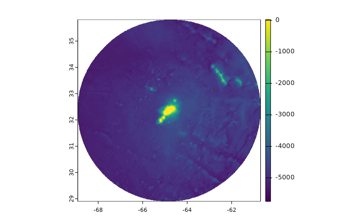
# Get raw bathymetry data, not classified into depth zones
bathymetry <- get_bathymetry(spatial_grid = bermuda_eez,
raw = TRUE,
classify_bathymetry = FALSE)
#> Downloaded and saved data chunk 1 of 1
#> Finished! Data successfully streamed to /tmp/RtmpHK44st/bathy_-68.92_-60.7_28.91_35.81.tif
terra::plot(bathymetry)
 # Get depth zones in spatial_grid
#equal area projection for Bermuda
bermuda_crs <- '+proj=laea +lon_0=-64.8108333 +lat_0=32.3571917 +datum=WGS84 +units=m +no_defs'
bermuda_grid <- get_grid(boundary = bermuda_eez,
crs = bermuda_crs,
resolution = 10000)
depth_zones <- get_bathymetry(spatial_grid = bermuda_grid)
#> Downloaded and saved data chunk 1 of 1
#> Finished! Data successfully streamed to /tmp/RtmpHK44st/bathy_-68.94_-60.68_28.9_35.81.tif
terra::plot(depth_zones)
# Get depth zones in spatial_grid
#equal area projection for Bermuda
bermuda_crs <- '+proj=laea +lon_0=-64.8108333 +lat_0=32.3571917 +datum=WGS84 +units=m +no_defs'
bermuda_grid <- get_grid(boundary = bermuda_eez,
crs = bermuda_crs,
resolution = 10000)
depth_zones <- get_bathymetry(spatial_grid = bermuda_grid)
#> Downloaded and saved data chunk 1 of 1
#> Finished! Data successfully streamed to /tmp/RtmpHK44st/bathy_-68.94_-60.68_28.9_35.81.tif
terra::plot(depth_zones)
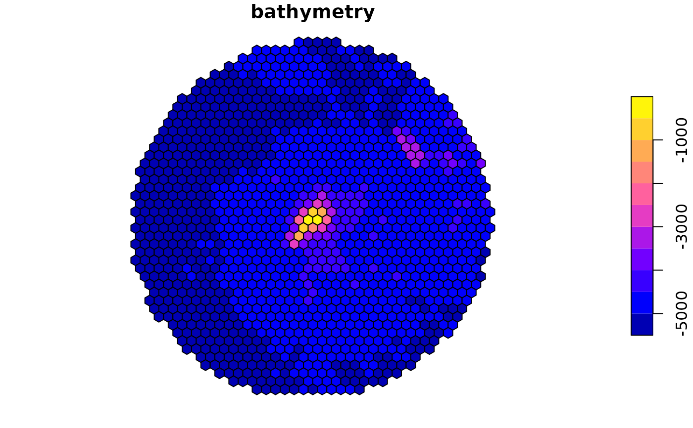
 #It is also possible to get the raw bathymetry data in gridded format by setting raw = FALSE
# and classify_bathymetry = FALSE
gridded_bathymetry <- get_bathymetry(spatial_grid = bermuda_grid,
classify_bathymetry = FALSE)
#> Bathymetry data already downloaded, loading data from: /tmp/RtmpHK44st/bathy_-68.94_-60.68_28.9_35.81.tif
terra::plot(gridded_bathymetry)
#It is also possible to get the raw bathymetry data in gridded format by setting raw = FALSE
# and classify_bathymetry = FALSE
gridded_bathymetry <- get_bathymetry(spatial_grid = bermuda_grid,
classify_bathymetry = FALSE)
#> Bathymetry data already downloaded, loading data from: /tmp/RtmpHK44st/bathy_-68.94_-60.68_28.9_35.81.tif
terra::plot(gridded_bathymetry)